Now on ScienceBlogs: ScienceOnline2010 - interview with Dennis Meredith

Read water posts on ScienceBlogs and download National Geographic's April WATER Issue

Eruptions

A blog of volcanic activity and research worldwide.

Profile

Dr. Erik
Hi! You're looking at Eruptions, a blog dedicated to volcanism. Your host is Dr. Erik Klemetti, a geologist who spends most of his professional time thinking about magma. Looking for info on the latest eruption? You've found the place.

If you like what you read, recommend Eruptions to friends and strangers on Digg, Slashdot, Reddit, Facebook, Technorati or wherever you like.

Search

Recent Posts

Recent Comments

Archives

Links

Volcanoes! Science Blogs - GeoStyle Geology!

Useful Stuff

Locations of visitors to this page

« Eruption started at Eyjafjallajökull in Iceland | Main | Eyjafjallajokull Update for 3/22/2010 »

The 2010 fissure eruption at Eyjafjallajokull

Category: Ash fallAviationBasaltic eruptionCurtain of fireEruption videoEyjafjallajökullEyjafjöllIcelandKatlaLakiMitigationVolcanic hazardsVolcano monitoringevacuationsspeculation
Posted on: March 21, 2010 10:25 AM, by Erik Klemetti


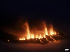
The fissure vent eruption on Eyjafjallajokull in Iceland on March 21, 2010.

The big news this morning is the eruption that started last night at Eyjafjallajokull in Iceland, producing a 1-km fissure vent. The pictures and videos I've seen so far have been quite impressive, with the classic look of a "curtain of fire", where basaltic lava erupts explosively from a linear array of vents - you can see the geometry in the image from the BBC/AP (above). Especially clear is the dual nature of the eruption, with both the explosive fire fountains and the effusive (passive) lava flows from the root of the curtain of fire. In many "curtain of fire" eruptions on Hawai`i, the curtain (see below) eventually coalesces into a single fire fountain, sometimes producing fountains that can reach a few kilometers in height. This will be something to watch for in the coming days if the eruption continues.

Here is some video taken last night of the fissure eruption - impressive stuff!


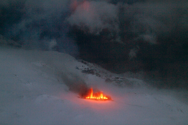
Daylight image of the 2010 eruption of Eyjafjallajokull.

Airspace over Iceland is closed for the moment, although these style of eruptions don't produce much of volcanic ash - although there is likely significant fine droplets of lava forming some ash fragments, Pele's tears and Pele's hair (all basaltic volcanic products). However, eruptions like this can emit a lot of volcanic gases like carbon dioxide and sulfur dioxide - much like this eruptions distant relative, the Laki eruption of 1783. And even though the eruption is explosive, the hazard to surrounding communities is relatively low unless the lava flows encroach on populated areas or there is significant ice/snow melt to produce lahars or a jokulhlaup. However, Icelandic authorities have evacuated hundreds of people from the region near the eruption as a precaution (with text messages no less!)

There has been a lot of coverage of the eruption on the internet, much of it in Icelandic, but now various American and British news sources have coverage (some better than others) as well. Of course, there is already speculation floating around the web as well, with some reports saying that Katla is likely to erupt as well. There is also news that tourists are already expressing interest in visiting areas near the eruption to take a look.

{Hat tip to all Eruptions readers for many of the links in this post.}

Share this: Stumbleupon Reddit Email + More

Trackbacks

Trackback URL for this entry: http://scienceblogs.com/mt/pings/134116

Comments (53)

1

Oh, that is *intensely* beautiful. Would there be a glacier-surface (or subglacial) river forming?

Posted by: Mary Mactavish | March 21, 2010 12:55 PM

2

Think you have a 'fissure' on your blog on this subject. Most seem to still be 'commenting' over at your earlier entry.

Is there a link to seismic data for this event that you're aware of?

Posted by: Pascvaks | March 21, 2010 1:16 PM

3

There is a lot of flux in the volcano eruption. It drops but then it builds up again. That behaviour might not be such surprise given the known eruption history of Eyjafjallajökull.

Posted by: Jón Frímann | March 21, 2010 2:48 PM

4

Timesonline quotes several Icelanders. For example: Pall Einarsson (University of Iceland): "This could trigger Katla, which is a vicious volcano that could cause both local and global damage" http://www.timesonline.co.uk/tol/news/world/europe/article7070239.ece

But there are no signs right no, that there is a connection to Katla, although the 3 historic eruptions of Eyjafjallajokull were connected to Katla. Let´s have an eye on him....

Posted by: Thomas Wipf | March 21, 2010 3:16 PM

5

The Icelandic Met Office shows a map with a pretty exact location of the eruption and is also giving the best summary of what was going on in the last 3 weeks: http://en.vedur.is/about-imo/news/2009/bigimg/1845?ListID=0

Posted by: Thomas Wipf | March 21, 2010 3:40 PM

6

The eruption is apparently actually occurring on an ice-free pass between Eyafyallajokull and Katla, but authorities must be already worried that new vents could open up on the glaciated flanks of Eyjafyallajokull.

Check this link out - http://www.earthice.hi.is/ - it shows the specific location of the currently erupting fissure. Also, an online summary of the current eruption can be found here: http://www.earthice.hi.is/page/ies_activity_Eyjafjallajokull

Posted by: Mike K | March 21, 2010 3:49 PM

7

I ignore the web for a few days to entertain visitors and look what I miss!

It will be interesting to see how long the fountaining continues. As Erik stated a fountaining along a rift can localize and produce a single fountain like Pu O'O which would be really spectacular.

Posted by: EKoh | March 21, 2010 4:07 PM

8

It is going to be interesting to see if the ISGPS ground uplift and horisontal deformation continues. http://hraun.vedur.is/ja/gps/predorb/index.html
I have a feeling that the eruption intensity we see now is not enought to reduce the pressure under the volcano. I lava outflow from the fissure will probably have to increase a bit in order to keep even steps with the magma inflow from below. Then the question is... Will the intensity of the current fissure just increase or will the fissures start to extend? And in that case, in what direction? I think I agree with Peter Cobbold on the guess that the fissure will start to extend westward. Time will tell, and it is really interesting to guess what is going to happen next. ;)

Posted by: Mattias Larsson | March 21, 2010 4:30 PM

9

Seismic activity is picking up again...

This thing is not done yet. Let's hope this fissure isn't propagating.

New vents may open.... or the worst may be if the fracture crosses the silicic magma chamber.

If this happens.... all bets are off.

Posted by: Volcanophile | March 21, 2010 5:13 PM

10

volcanophile: I asked a question on that very possibility on the other thread..check out the answers (from Erik and Boris especially)

Posted by: mike don | March 21, 2010 5:41 PM

11

You may find this audio article published a few months ago on this very subject interesting. http://www.youtube.com/watch?v=C14AKwTDXLg

Posted by: Steve | March 21, 2010 6:11 PM

12

Off Topic but to nice to pass up...! Time dependent.

Tonight on Redoubt's Drift river cam shot!

What a beautiful tempest!

http://www.avo.alaska.edu/webcam/redoubt-3.jpg?0.7752140693122571

Posted by: JDZ | March 21, 2010 8:55 PM

13

Posted in other thread, but I believe this to be important so I will post here as well.

Vatnajokull in the last hour has had three quakes the largest very shallow an m3.4 unresolved.

http://en.vedur.is/earthquakes-and-volcanism/earthquakes/vatnajokull/#view=table

Posted by: JDZ | March 21, 2010 10:13 PM

14

I would really like to know how to pronounce the name of this volcano! Can anyone post a phonetic pronunciation guide?

Posted by: Gayle | March 21, 2010 10:54 PM

15

@Gayle, we had a round about the pronounciation of Eyjaf and did not come to much conclusion. I know this isn't correct, but the best I can do is: Eh-yaf-jalla-jokole.

Now you Icelanders, please don't get on my case. LOL I do the best I can. One reason I shortened the name to Eyjaf, which I pronounce Eye-jaf (Iknow, I know, I am doing disjustice to your language). Am I correct, though, that the first "j" is pronounced "ya" and not "ja"? And the js are not hard sounding? Just trying again. (red in face) :-}

Posted by: Diane | March 21, 2010 11:40 PM

16

Diane, I believe it's (h)ey-yaf-yalla-yo-kül (silent h and german ü), based on my knowledge of swedish (but that doesn't help much, I'm told)

Posted by: jyyh | March 22, 2010 12:51 AM

17

Eyjafjallajokull (AYA-feeyapla-yurkul)

Posted by: Altair | March 22, 2010 1:37 AM

18

There appears to be a change happening. There was a explosion in the eruption site and the ash cloud did reach 4 km high.

Posted by: Jón Frímann | March 22, 2010 4:06 AM

19

Just spotted some newish footage from the AP/RUV which includes the night footage with some brighter (dawn?) video:

http://www.youtube.com/watch?v=bcUa_g_XVrQ

Posted by: Suw | March 22, 2010 5:02 AM

20

New report from Iceland Review. Calls it 8 km plume height, but only one burst which has now been reduced to 'small puffs'. Fissure now 2 km length.

http://icelandreview.com/icelandreview/daily_news/?cat_id=29314&ew;_0_a_id=359689

Posted by: Eric | March 22, 2010 5:16 AM

21

Nice photo of the eruption cloud at http://www.ruv.is/sites/default/files/myndir/mokkur3landscape_0.jpg

Posted by: Henrik | March 22, 2010 6:15 AM

22

The eruption is now feeding a continuous plume as seen on the webcam (4/6 km high at first look)

OK.. so we just had the basaltic part of the eruption... Based on Eyjaf's history, this fissural basaltic dyke has probably cut through the main silicic magma chamber...

So we can expect big things to come next, depending on what's in this chamber...


Kind of like Hudson, 1991...

Posted by: Volcanophile | March 22, 2010 6:50 AM

23

Also interesting is monitoring the rivers in the area

There's an online interface for reading the data here: http://vmkerfi.os.is/vatn/VV_Frame.php

Click on Mýrdalsjökull in the sites panel and then select Krossá in the river selector and you'll see that the temperature of the water has gone up around 3.5 degrees in just a few hours and the water level spiked this morning but is still trending upwards.

Posted by: Sigga | March 22, 2010 6:56 AM

24

Now we have a continuous dense plume which is spreading flat at the top...

This is no more hawaian. This is subplinian activity.

The volcano may be starting to tap into the silicic magma chamber.

Posted by: Volcanophile | March 22, 2010 6:58 AM

25

For those who want to follow it live, the Hekla webcam has been trained south towards Katla (left) & Eyjafjöll (right) with the eruption site at centre:
http://reykjavik.mydestinationinfo.com/en/hekla-volcano-webcam

Posted by: Henrik | March 22, 2010 7:04 AM

26

So far this eruption looks pretty minor. Especially given all the hype leading up to it.

Posted by: mike | March 22, 2010 7:14 AM

27

@mike, given the history. Volcano eruptions in Eyjafjallajökull usually start small but end big it seems. If that happens however remains to be seen.

Posted by: Jón Frímann | March 22, 2010 7:25 AM

28

@Volcanophile and everybody who's been startled by the large plume at Eyjafjallajökull this morning - this looks like a short-lived phreatic or phreatomagmatic event, from a look at the photos available on the web. This is something that does happen during effusive eruptions in snow-covered area, and we've seen this on Etna a number of times when it erupted in the winter. Nothing to worry about if you're at a safe distance - which everybody seems to be in this moment :-)

People are beginning to post their photos (and somethimes those of others found on the net) on various photo sites. Quite a few beautiful ones are on Flickr, both eruption images and shots showing the volcano before the eruption, all useful to get a clearer idea of how that place looks like. The following link is the search results page, in chronological order (most recent first):

http://www.flickr.com/search/?s=rec&ss;=1&w;=all&q;=Eyjafjallaj%C3%B6kull&m;=text

One final thing. Long ago a friend of mine gave ma a short course on Icelandic pronounciation, and I still remember the essential bits - each time you come across a double-l ("ll") in a word, it's pronounced like "tl" or "dl", but without "humming" the "l", it's practically noiseless when it's at the end of a word (like "jökull" or "fjall"). Our volcano here would be pronounced, more or less, something like "Ayh-yah-fyat-lah-yeh-kit(l)". Accent is on the last syllable but one ("yeh"). The Icelanders among you, please correct me if this is wrong.

Oh, and a big thanks to all of you for the various links and the very interesting discussion here.

Posted by: Boris Behncke | March 22, 2010 7:29 AM

29

for those interested in the river monitoring system in the vicinity Eyjafjallajokull i like to point out the following web page:
http://vmkerfi.os.is/vatn/VV_Frame.php?r=27398&load;_graph=1&direct;=1&station;_id=222&station;_name=Austurland&page;_id=338
of interest is the increasing temperature from around 1C to 7.5C in the river Krossa at around noon GMT. This event was superseeded by a flooding that started around 8:30 this morning (top graph, showing water height).
einar

Posted by: einar | March 22, 2010 9:08 AM

30

apologies with regards to the reference above. does not link directly to river Krossa. the way to it is to press first on
Site > Myrdalsjokull and then
Pages > Krossa
btw: river Krossa is north of Eyjafjallajokull and feeds into the larger Markarfljot.
einar

Posted by: einar | March 22, 2010 9:26 AM

31

Re #25 Hekla webcam pointing south - disregard. It seems the view has now changed back to Hekla.

Posted by: Henrik | March 22, 2010 9:37 AM

32

Iceland Review has some video from this morning:

http://http.ruv.straumar.is/static.ruv.is/vefur/Gos_Fljotshlid.wmv

Posted by: bruce stout | March 22, 2010 10:58 AM

33

@Boris, Etna sure is steaming away. In the years since I have been watching I don't remember it doing that. That was a neat picture on that site you gave us. I wonder just how much CO2 it is releasing now!

Thank you for your contributions, too. I seem to always learn something from you.

Posted by: Diane | March 22, 2010 11:52 AM

34

The river-monitoring page is unlikely to work - it's trying to load something hosted on a machine with an IP address in the private 10.0.0.0/8 range, which shouldn't be announced into the global routing table and in fact hasn't been. It probably works inside the organisation that runs it, but private addresses aren't globally unique, so people outside will get nothing, or whatever there happens to be using that address on their network.

Posted by: Alex | March 22, 2010 12:01 PM

35

At least from Iceland I get access to it. I put a screenshot on my webpage, here you can see the level and temperature level of the Krossa: http://temp.snaefell.de/krossa.png

Posted by: Chris | March 22, 2010 12:15 PM

36

Thank you, Altair.

Posted by: Diane | March 22, 2010 12:17 PM

37

Ahh, thanks for posting outflow and temp data Chris. I was looking for this data a couple of days ago, pre-eruption.

Posted by: Passerby | March 22, 2010 12:40 PM

38

Mystery solved; you need to log in at http://vmkerfi.os.is/, just copying the username and password given as examples, and it will send you to the real server (on 130.208.87.147)

Posted by: Alex | March 22, 2010 12:43 PM

39

Using Google translate is problematic for signing in. Translate 'water height' and 'flow' into Icelandic, please, Alex. I'd like to cast a professional eye over meltwater depth and temperature data pre-eruption, from March 17 onward.

Posted by: Passerby | March 22, 2010 12:56 PM

40

@passerby: Passwort and Username are stated on the site:
notendanafn: vatnshaed (Username)
lykilorð: rennsli (Password)

Posted by: Chris | March 22, 2010 12:59 PM

41

translation icelandic > english
vatnshæð > water height
leiðni > conductance
vatnshiti > water temperature
lofthiti > air temperature
einar

Posted by: einar | March 22, 2010 1:05 PM

42

In case, you don't get in, I generated a view of the last week: http://vmkerfi.os.is/vatn/Index.php
Yo cann see the temperature changing through the day, but that looks different from what happened today.

Posted by: Chris | March 22, 2010 1:06 PM

43

That's what I tried, several times. After login, the webpage spins uselessly, just as it does when trying to access the ISP (numerical addy)supplied.

Thanks for your patient help, anyway.

Posted by: Passerby | March 22, 2010 1:09 PM

44

@passerby
try: http://vmkerfi.os.is/vatn/
instead of http://vmkerfi.os.is/vatn
seems to make quita a difference.
einar

Posted by: einar | March 22, 2010 1:21 PM

45

Sorry, I entered the wrong link: http://temp.snaefell.de/krossa.pdf

Posted by: Chris | March 22, 2010 1:27 PM

46

Ah, that's what I wanted to see: jump depth change, right when we saw the major shift in activity between March 16-18th, and the telltale jump in Q (flow), depth and T.

Photo of the braided river channel
http://en.wikipedia.org/wiki/%C3%9E%C3%B3rsm%C3%B6rk

Posted by: Passerby | March 22, 2010 2:41 PM

47

I have added a post to my blog showing the eruption location N63º 38.1', W19º 26.4' (taken from Smithonian Institute) in 2 Google Earth satellite views.
http://rudipo.blogspot.com/2010/03/google-earth-view-of-eyjafjallajokull.html
The eruption seems quite near to the famous walking trail over Fimmvördurhals where also a hut is standing. Has somebody more information about the exact distance to the hut?
Greetings Rudolf

Posted by: Rudolf Posch | March 23, 2010 10:00 AM

48

Rudi, great link with insightful Google graphic.

If you jump up to the thread post above this one, on the Eruptions Blog, you will see a comment by Anna, posted earlier today. She provides a link to a large, detailed topo map of the hiking path. It not only indicates the location of the hut, but it also clearly shows the interesting crater features that you point out in your own blog.

I suspect those features are important to understanding this fissure eruption.

Posted by: Passerby | March 23, 2010 4:42 PM

49

@Rudolf: Fimmvörðuháls is a kilometer further south. The hut is approximately 1.5 km south of the eruption.

I have put the location of the hut and the eruption, as well as the map of the lava flow into a KML file at:
http://bbs.keyhole.com/ubb/ubbthreads.php?ubb=download&Number;=889223

Posted by: Thomas Nygreen | March 23, 2010 7:03 PM

50

Correction: I was unaware that one had to be logged in to the forum to download the attachment, so I have also uploaded it to my university webspace:

http://folk.uio.no/thomanyg/eruption.kml

Of course you also need Google Earth to view it. (you can also use it with google maps to view the locations, but not the overlay image)

Posted by: Thomas Nygreen | March 23, 2010 7:50 PM

51

Thanks Passerby. Thanks Thomas, I have looked into Google Earth with your KML file, great! The eruption spot coincides with the Smithonian cordinates I have. Your provided lava flow fits perfectly into the 3D landscape. And you overlayed a map with contour lines (in German "Höhenlinie") into the Google Earth satellite view, who fit perfectly with the Google Earth 3D satellite view! How is this done?
In the mean time I looked at
http://en.vedur.is/media/jar/myndsafn/medium/eyfj20100321.png
, very intersting.
Also I read at some link I do not find any more

“Lava spurted from the fissure and there is now a large lava field extending towards Thórsmörk. The volcanic jets seemed mighty powerful and a beautiful volcanic rim was starting to form,” Kjartansson described.
He said the eruption is located directly on the popular hiking path which leads across the Fimmvörduháls pass—the sticks marking the path go straight into the crater. So the path must be marked again next summer, provided the eruption will have stopped by then."
So its amazing today. I am sitting far away from Iceland in Austria and have all the means by the web to view pictures, blogs, newspaper articles, maps and so on about the eruption!
Greetings to your beautiful country Rudolf

Posted by: Rudolf Posch | March 24, 2010 3:58 AM

52

Icelandic has a lot of compound words - Eyjafjallajökull is one of those. Eyja = islands, fjalla = mountains, jökull = glacier. Maybe this helps a bit with the pronounciation.

Posted by: Ragga | March 24, 2010 6:06 AM

53

I tried to match a photo from the eruption from the Iceland Met Office with a Google Earth satellite view.
The result you my see in my blog
http://rudipo.blogspot.com/2010/03/fimmvordurhals-eruption-foto-google.html
The Google Earth view uses a .kml file provide by Thomas Nygreen (see above in this comments).
Greetings Rudolf

Posted by: Rudolf Posch | March 24, 2010 6:42 AM

Post a Comment

(Email is required for authentication purposes only. On some blogs, comments are moderated for spam, so your comment may not appear immediately.)

ScienceBlogs

Search ScienceBlogs:

Go to:

Advertisement
Read ScienceBlogs WATER posts and download National Geographic's Water Issue.
Read ScienceBlogs WATER posts and download National Geographic's Water Issue
Advertisement
Collective Imagination

© 2006-2009 ScienceBlogs LLC. ScienceBlogs is a registered trademark of ScienceBlogs LLC. All rights reserved.